
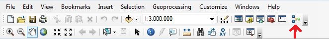
Ever have trouble conceptualizing your project workflow? ModelBuilder allows you to plan your project before you run any tools. When using ModelBuilder in ESRI’s ArcMap, you create a workflow of your project by adding the data and tools you need. To open ModelBuilder, click the ModelBuilder icon (![]() ) in the Standard Toolbar.
) in the Standard Toolbar.
Key Points Before You Build Your Model
ModelBuilder can only be created and saved in a toolbox. In order to create your model, you first need to create a new toolbox in the Toolboxes, MyToolboxes folders in ArcCatalog. Once you have a new toolbox, you will need to create a new Model; to do this, right click your newly created toolbox and select New, then Model. When you wish to open an existing ModelBuilder, find your toolbox, right click your Model and select Edit.
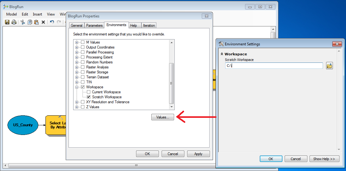
In order to find the results of your model and the data created in the middle of your project workflow (also known as intermediate data), you will need to direct the data to any workspace or a Scratch Geodatabase. To set your data results to a Scratch Geodatabase in ModelBuilder, click Model, then Model Properties. A dialog box will open and you will want to select the Environments tab, Workspace category, and check Scratch Workspace. Before closing the dialog box, select “Values” and navigate to your workspace or your geodatabase.
Building and Running a Model
To create a model, click the Add Data or Tool button (![]() ). Navigate to the SystemToolboxes, find the tool you wish to run, and add it to your model. Double click the tool within the Model and its parameters will open. Fill out the appropriate fields for the tool and select OK.
). Navigate to the SystemToolboxes, find the tool you wish to run, and add it to your model. Double click the tool within the Model and its parameters will open. Fill out the appropriate fields for the tool and select OK.
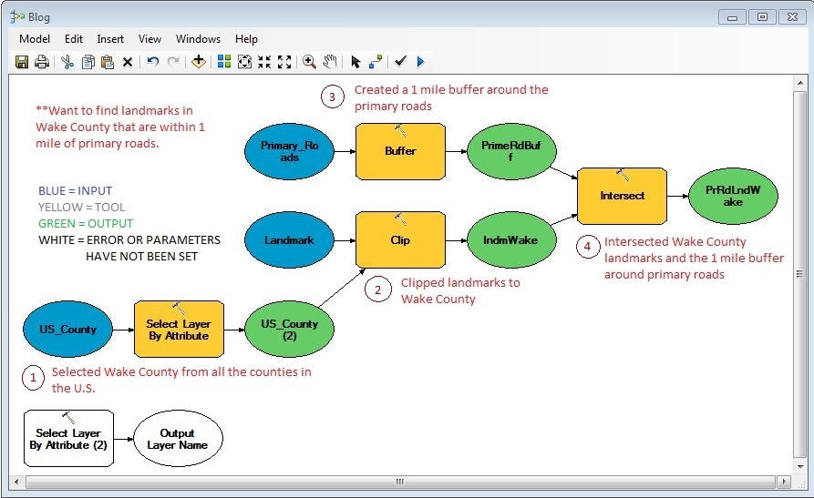
When the tools or variables are ready for processing, they will be colored blue, green, or yellow. Blue variables are inputs, yellow variables are tools, and green variables are outputs. When there is an error or the parameters have not been chosen, the variables will have no color.
Once you have your model built, click the Run icon (![]() ) to run the model. Depending on the data and the amount of tools you run, the Model can take seconds or minutes to run. You can also run one tool at a time; to do this, right click the tool and select “Run.” When the Model is done running, the tools and outputs will have a gray background. To find the results of your model, navigate to the Scratch Workspace you have set and add the shapefile or table to ArcMap or right-click the output variable before running the model and select “Add to Display.”
) to run the model. Depending on the data and the amount of tools you run, the Model can take seconds or minutes to run. You can also run one tool at a time; to do this, right click the tool and select “Run.” When the Model is done running, the tools and outputs will have a gray background. To find the results of your model, navigate to the Scratch Workspace you have set and add the shapefile or table to ArcMap or right-click the output variable before running the model and select “Add to Display.”
Applying ModelBuilder
The model above demonstrates how to take nationwide county data, North Carolina landmark data and North Carolina major roads data and find landmarks in Wake County that are within 1 mile of major roads. The first tool in the model (Select Layer by Attribute tool) extracts Wake County from the nationwide counties polygon layer. 
Once Wake County is extracted to a new layer, the North Carolina landmarks layer is clipped to the Wake County layer using the Clip tool.  The result of this tool creates a landmarks point layer in Wake County. The third tool uses the Buffer tool on the primary roads layer in North Carolina. Within the Buffer tool parameters, a distance of 1 mile is chosen and a new polygon layer is created.
Finally, the Wake County landmarks layer is intersected with the buffered major roads layer to create a final output using the Interect tool.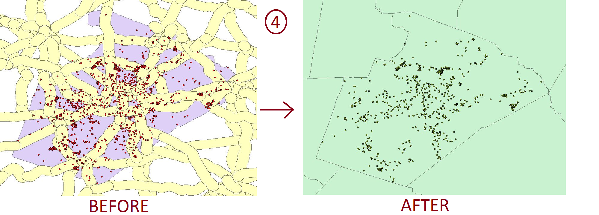 Using ModelBuilder has many benefits: you document the steps you used to create your project and you can easily rerun the tool with different inputs after the model is built. ModelBuilder allows users to easily determine if and where problems in the workflow are. When there is an error in the workflow, a “Failed to Execute” message will appear and tell users which tool was unable to execute. ModelBuilder also lets users easily change parameters. In the model used above, you could change the Expression in the Select Layer by Attribute tool from ‘Wake’ to ‘Durham’ and find landmarks within 1 mile of major roads in Durham County.